Network Centric Software

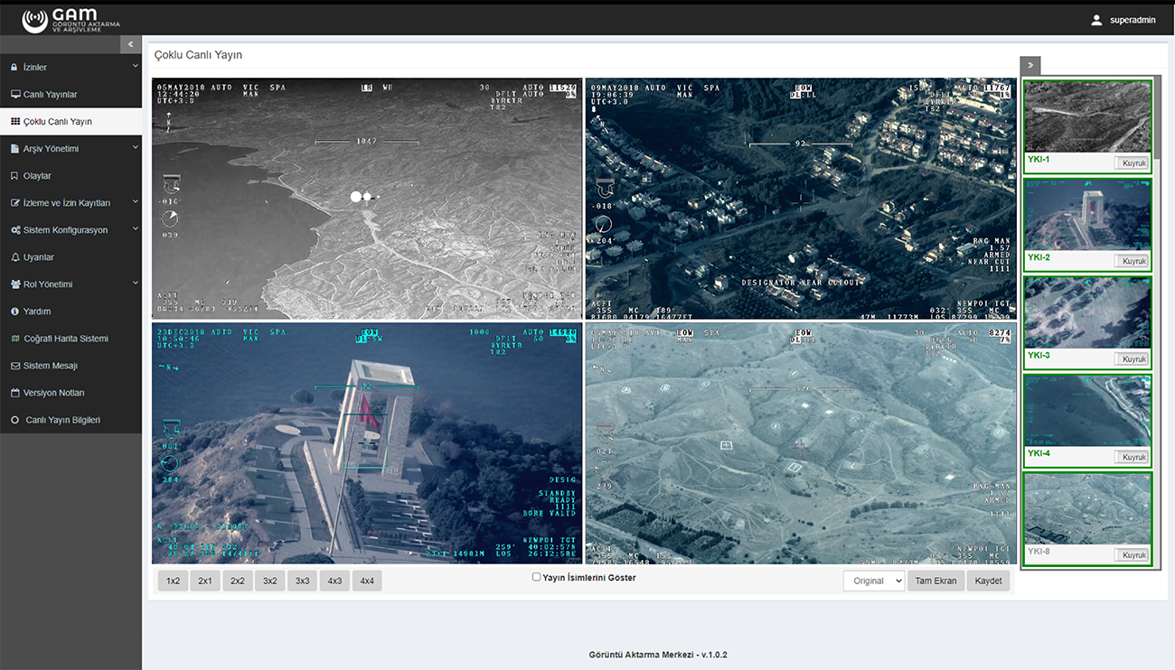
The Image Transfer Center (GAM) is designed for simultaneous multiple user viewing of live images taken from air and land platforms within users' permissions.
It uses media server software to transfer images in the background. Due to the web-based interface and image options in different resolutions, GAM provides quality and seamless image delivery to the end-user at low bandwidth.
Before air and land platforms start their operational activities, the authorized personnel grant user-based permissions and manage the whole process quickly through the user-friendly interface.
Users with viewing permission granted by the authorized personnel can also request permission to broadcasts they are not authorized to; permissions will automatically be revoked upon the completion of the operation.
The system automatically stores all broadcasts that can be viewed from GAM on media servers. Along with the archive videos, also the start and end date of the operation, the geographical location where the operation took place and the notes made by the personnel are stored in the archive, which increases the value of the archived broadcasts.
- Live Streaming
- Video Archiving
- User Authorization
- Event Management
- Security and Infiltration Prevention
- Easy and Effective System Management

KUZGUN is a system that provides instantaneous transferring of live broadcasts taken from air and land platforms from the secure network to the mobile internet network in an end-to-end encrypted manner.
It increases the coordination and visibility between the command and control center and the elements operating in the field, enabling necessary measures and offensive decisions to be taken faster.
In a point of fact, by providing instant intelligence to the military units and security elements in the mission regions, U(C)AVs strengthen the communication between the tactical area and the command and control center.
Through Kuzgun, the mobile video imagery transmission system integrated with GAM, the broadcasts on the secure network are transmitted on the internet to mobile devices in an encrypted manner and without delay. Due to the high-quality but low-bandwidth broadcast options, high-quality and seamless broadcasts can be viewed over mobile networks.
- Low Bandwidth
- End-to-End Encryption
- Packet Filtering Solutionv
- One-Way Data Transfer
- Active Broadcast and Device Management
- Remote Update
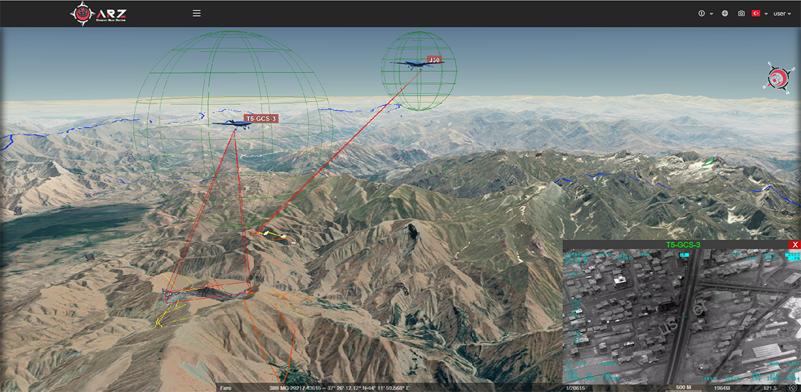
ARZ is a new generation 3D virtual globe application of a Geographic Information System. Having a flexible structure and handy interface, the Geographic Information System of ARZ provides solutions to GIS needs in the field of defence technologies. ARZ GIS application can easily integrate with defence systems and provides those systems with GIS capabilities.
ARZ application offers basic Geographic Information System (GIS) software capabilities to users. Carrying such features as raster layers, vector layers, high-resolution terrain model on a 3D globe, real satellite image, layer and user management, and 3D modelling, the ARZ GIS application meets the needs of its user.
The ARZ GIS application integrates with the Unmanned Aerial Platforms and provides instant access to the UAV location and target information. The information delivered from the UAV platform is accessed through the ARZ application.
Users can create vector data on the map by adding objects to the map. Due to integration with other systems, objects with location information can be automatically viewed on the ARZ application. The system can be easily managed through effective authorization solutions, using layer and object-based authorizations.
By conducting spatial searches on the ARZ application, one can make archive inquiries through the objects and aerial platforms that had missions in that location in the past.
- Vector and Raster Layer
- Terrain Model on a 3D Globe
- Spatial Inquiry
- Address Information System
- Authorization Mechanism
- Real Satellite Images
- Layer and User Management
- Flight Simulation
- 3D Models


SAHIN integrates with imaging systems of UAVs and armoured vehicles and performs real-time data processing and analysis by images.
SAHIN application integrates with defence systems and creates intelligence data by performing motion detection, target identification and tracking by images and instant image evaluation.
In the defence industry applications, detection of terrain changes, hard-to-see movements, thermal changes and pixel-based changes on the image screen is made by SHAHIN Image Processing System. Moreover, it performs target tracking and records tracking information on targets.
- Real Time Video Processing
- Motion Detection
- Advanced Target Tracking
- Object Classification
- Geo-Indexing
- Archive Image Evaluation